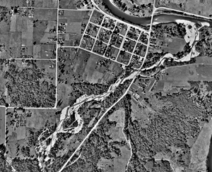
We are grateful to Johann Sasynuik for calling this article from Pacific Builder and Engineer, c1940 to our attention and sharing a copy with us. (Courtesy of University of Washington Suzallo Library.) Use this link to see images of the two pages of the article, including several photos, unfortunately of poor quality in the copy. The text is transcribed below. A comparison of Aerometrics/Seattle aerial photos from 1936 and 2004, was published in the June 2008 Fall City Neighbors Newsletter.

Article in Pacific Builder and Engineer c1940
How King County Controlled Raging River
by Harry H. Sisler, Road Engineer for King County, Wash.
Located in the eastern part of King County, Wash., and tributary to the Snoqualmie River, Raging River has been one of the greatest sources of worry for county officials for the past 25 years. This stream, receiving the drainage of a watershed 35 sq. miles in area, rises in the territory above Preston. At times this watershed has considerable snow fall, which, melting with the warm winds and rain, causes a very flashy and quick runoff down the river.
The upper gradient of the river is very steep, with a velocity of approximately 12 ft. per sec., causing this stream in its upper reaches to become a raging torrent during times of heavy runoff. Emerging from the mountainous section approximately 1 ½ miles southerly from the town of Fall City, it takes a winding course over a wide stretch of delta. It formerly went through what is now the town of Fall City, but its course was altered years ago in some respects, due to the development of the city itself.
GRAVEL DELTA – An immense quantity of gravel had been brought down stream by the high velocity of its water, causing a gravel delta to form in the lower reaches, in some cases as great as 10 ft. The people of Fall City have been apprehensive that the river would tend to seek its former channel and cause an immense amount of damage by flooding the town. For the past 20 years, residents of Fall City have continued to petition the Board of County Commissioners to undertake corrective measures on this stream to prevent a catastrophe, which would result from the flooding of the town. Their efforts were unsuccessful until the election of Mr. Tom Smith as Commissioner, who made this one of the important planks in his platform. Accordingly late in the Fall of 1937, Commissioner Smith instructed the County Engineer to take steps to correct the situation.
Summary of project: After approval of plans for the deepening, widening, and straightening of the lower 1 ½ miles of the stream, actual channel construction was begun on July 1, 1938 and continued through the end of that year, then resumed in March 1939. The channel was first rough-graded by dredging, then the banks were trimmed and the dikes leveled. The approximate total amount of gravel taken from the river bed in the course of these channel operations was 125,000 cu. yds. Starting in March 1939, the placing of rock rip rap on the banks was begun at the upstream end of the channel, and carried forward down stream as the dredging proceeded. The rock was obtained from the Fall City Quarry under a royalty agreement with the owners, and was produced in conjunction with the WPA operations on the Snoqualmie River. 29,000 cu. yds. of heavy rock were used in the project.
(Article courtesy of University of Washington Suzallo Library.)

Visit previous Feature Articles:
- Safely Clean and Restore Cemetery Headstones
- Black History Month
- Fall City: The Grocery Corner
- Fall City Schools Part 1: Early Schools
1873 through 1915 - Falls City Masonic Hall
- Neighbor-Bennett House
- The Bridges of Fall City
- Construction of Raging River Dike, 1938-39
- Fall City featured in The Coast magazine
- Raging River Auto Camp
- Falls City Depot Station
- Origins of lower Lake Alice Road


