Origins of lower Lake Alice Road
Expanded from Jan. 2013 Fall City Newsletter article.
Lake Alice Road received attention in the fall of 2012, when it was closed briefly to make interim repairs on a very old culvert just uphill from the entrance to Heathercrest. Further closure will be necessary in summer of 2014.
In 1889, the Seattle, Lakeshore and Eastern Railroad tracks passed near Fall City, and a depot was constructed at the site of the current trail parking lot near SE 56th and Lake Alice Road. In 1889, Doc Taylor petitioned King County to have a road built to improve access to the depot. No maps of this road are available, but its assigned number, County Road #234, is recorded and becomes part of the next stage of road building.
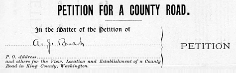

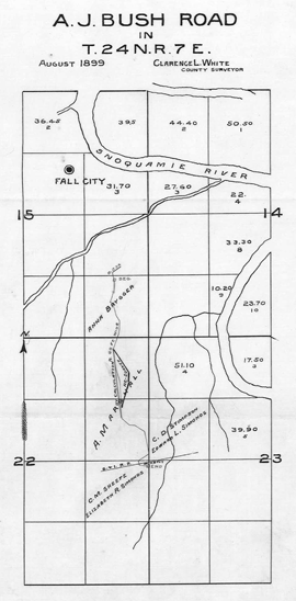
On April 18, 1899, Andrew J. Bush submitted a petition in his name and in the names of about fifty other residents of the Fall City area to establish an improved road to the depot. The County Commissioners accepted the petition and appointed "viewers" to work with a county surveyor and lay out the proposed road. A Viewer's Report was submitted on September 16, 1889. It summarized the proposed route, for a road 60 feet wide and 4465 feet in length, and listed four parcels of land that would be crossed, with estimated damages of $125 due to Augustus Marshall, whose land was most affected. The summary read:
This road is in part a relocation of Road #234 for the purpose of lessening the grade between Falls City and the Falls City Depot, over which road practically all the travel from this portion of the Snoqualmie Valley passes. The grade on the present travelled road is in great part adverse and some of it so heavy as to make freight transportation between Falls City and said Depot very much more expensive than a possible lighter grade would necessitate. For this reason we think the road a necessity. One bridge about 100 feet long and averaging 20 feet in height will be needed. Ten fruit trees will be taken into the road on the place of A. Marshall.
The bridge recommended is to cross a deep gulch shown on the surveyor's elevation map, which is no doubt the ravine where the culvert is now needing to be replaced. It is not clear if a bridge was built, or if the present culvert was put in at that time.
The earlier Road #234 had also crossed Mr. Marshall's land. The process began in 1889 and it was not until 1897 that he finally sold the right-of-way for that road to King County. He was understandably not pleased when asked to grant right-of-way for yet another road. Below is the text of a letter sent by him on April 22, 1901:
To the Hon. Board of County Commissioners
Gentlemen
As you have not taken any of my offers regarding the road through my place - I now cancel all the offers I have made. If it is worth two hundred dollars to have the road on the west side of the house it is worth that to have it on the east side. Now if you want the road on the east side of the house you can put it there for two hundred dollars or you can let me choose a man and you choose one and they choose a third and have them view both routes of the road on both sides of the house and we will abide by their decision as to what the damages should be.
Now if you don't want to do that way you can go on with your confiscating business. If I have to let the County have a road just where they want it whether it suits me or not they will just have to confiscate it and take it. I once took my musket and went to protect our government and what little I have now has to be confiscated to please a few fellows that never heard a blue whistler sing they will have to take it when I see them take it so I will know how it is done.
—Yours very resp. A. Marshall
His recommendation for choosing three arbitrators seems to have been adopted. A report from the arbitrators (G.D. Rutherford, G.W. Stephenson and J.T.Magee) was submitted on May 20, 1901, saying they had awarded Mr. Marshall $250 in damages. And the final surveyor's map notes that it was changed to reflect the final alignment through Mr. Marshall's property.
Many thanks to the helpful folks at the Washington Department of Transportation Map Vault. For more extensive background and scans of the early handwritten documents, see the 49-page pdf A J Bush Rd 1899-MapVault-72 dpi or AJ Bush Road 1899 Summary .
Visit previous Feature Articles:
- Safely Clean and Restore Cemetery Headstones
- Black History Month
- Fall City: The Grocery Corner
- Fall City Schools Part 1: Early Schools
1873 through 1915 - Falls City Masonic Hall
- Neighbor-Bennett House
- The Bridges of Fall City
- Construction of Raging River Dike, 1938-39
- Fall City featured in The Coast magazine
- Raging River Auto Camp
- Falls City Depot Station
- Origins of lower Lake Alice Road